The Boyd Gate House1125 B Street San Rafael |   |
Great Heights: The Aerial Photography of Ed Brady
This exhibit consists of 18 stunning black and white aerial photographs of Marin County from the 1950s and ‘60s, a time of rapid growth and development. Aero Photographers, a company started by radio personality and WWII veteran Ed Brady and his cohort Jack Van Wart in the late 1940s, documented the Bay Area from the air for nearly four decades, creating a vast and important visual record that continues to be appreciated and accessed regularly by all kinds of researchers. Ed Brady’s love for Marin County, his home, is clear in this carefully curated survey of his company’s work.
You can purchase digital copies of these photographs at our Purchase a Photograph page. Please reference the Photo ID number when ordering.
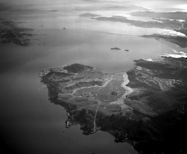
Angel Island, c. 1954
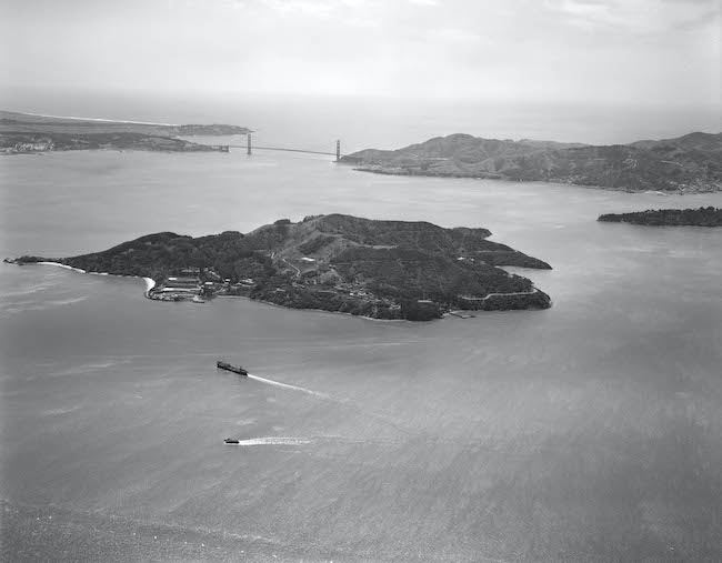
A tranquil westward view of Angel Island from over San Francisco Bay. The iconic Golden Gate Bridge, linking San Francisco to Marin County, is seen beyond.
Notice the undisturbed peak of Mt. Livermore, the highest point on Angel Island. The peak was flattened by the U.S. Army in 1955 for the construction of the SF-91 Nike Missile Base, and restored in 2002.
Photo ID no. 2006.34.00161
Golden Gate Bridge, c. 1954
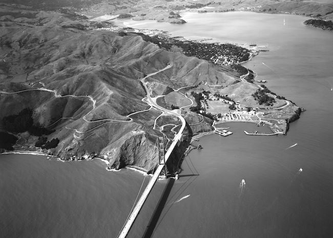 You are flying northward over California’s Golden Gate, its famous bridge below you. Horseshoe Bay and adjacent Fort Baker are seen to the right; Sausalito and Marin City are seen beyond, bordering Richardson Bay.
Notice the single bore Waldo Tunnel at the top of Waldo Grade (now the rainbow-decorated Robin Williams Tunnel).
Photo ID no. 2006.34.00175
Tiburon Peninsula, c. 1955
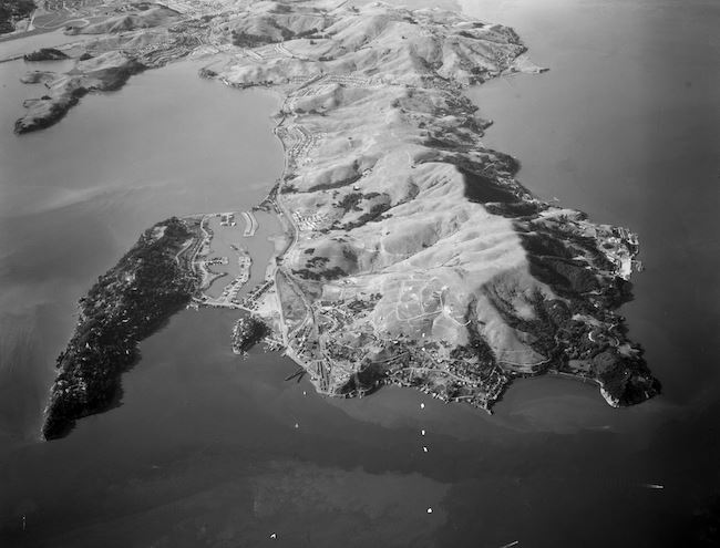
Soaring westward over Angel Island you take in the geography of the entire Tiburon Peninsula. Belvedere’s shady arm extends to the left; Ring Mountain, at the top of the peninsula’s backbone, looms over Paradise Cove.
Notice the Tiburon train yard at Point Tiburon near the middle of the frame. The train yard was demolished in 1967.
Photo ID no. 2006.34.00747
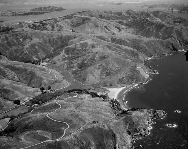
Mill Valley, Strawberry Point, West Marin, 1966
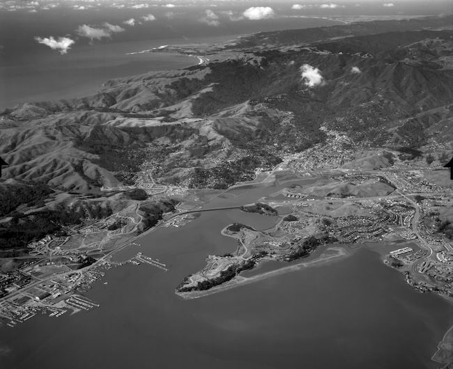 You are flying northwest over Richardson Bay, approaching Mill Valley. Sausalito to the left and Strawberry to the right are seen in your immediate view; Drake’s Bay and Point Reyes are seen in the distance along Marin’s west coast.
Notice Aramburu Island, adjacent to Strawberry Spit, created in the early 1960s with dredged material from nearby developments and now a sustainable bird habitat.
Photo ID no. 2006.34.10384
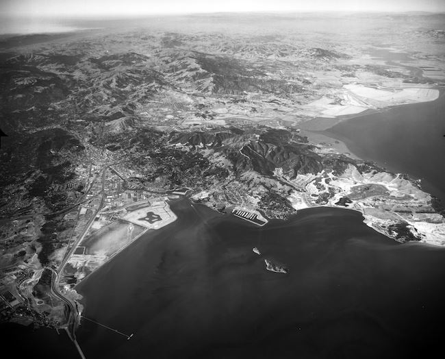
San Francisco and Marin County, 1959
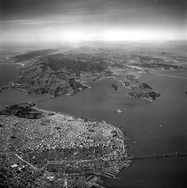 You are fifteen thousand feet over San Francisco, the entirety of Marin County spread out before you. Three Bay Area bridges, the Golden Gate to the left, Bay Bridge to the south, and three-year-old Richmond-San Rafael Bridge are all seen in one stunning frame.
Notice Alcatraz Island midway between San Francisco’s Fisherman’s Wharf and Angel Island.
Photo ID no. 2006.34.04216
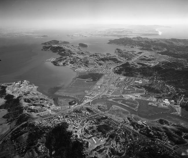
Southern Marin County, 1959
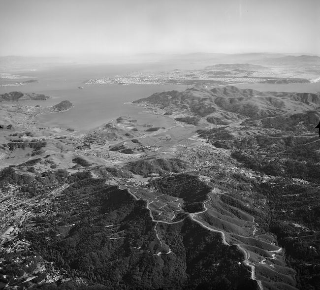 Skimming over the peak of Mount Tamalpais you see a magnificent view of southern Marin County. Tiburon, Belvedere, and Angel Island are to your left; Strawberry Point is centered in the frame below Sausalito.
Notice Highway 101, with its clover-shaped interchange, cutting a diagonal line through Mill Valley.
Photo ID no. 2006.34.04225
Central Marin Looking East, 1959
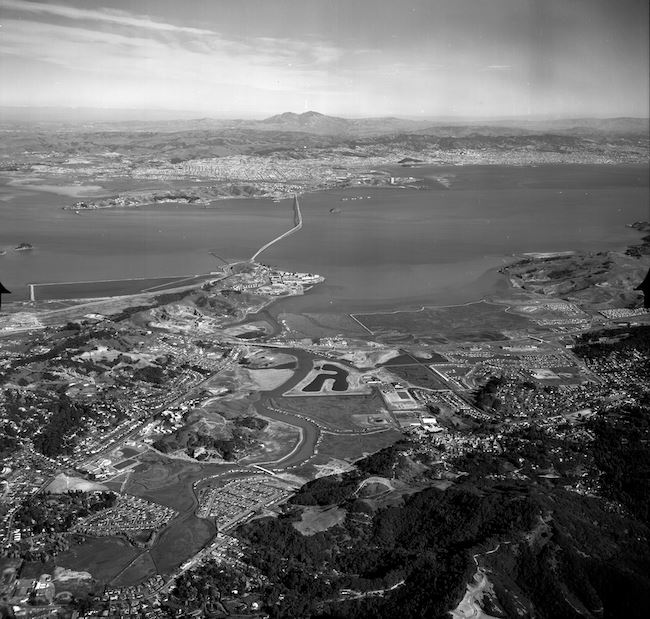 You are flying east over Kentfield and Greenbrae to your left and Larkspur and Corte Madera to your right. San Quentin Point and the newly built Richmond-San Rafael Bridge lie ahead.
Notice Redwood High School adjacent to an undeveloped Larkspur Marina, and Marin Catholic High School to the left along Sir Francis Drake Boulevard.
Photo ID no. 2006.34.04225
Corte Madera and Larkspur, 1960
 You are viewing Corte Madera and Larkspur while flying northwest over San Francisco Bay. The eastern slopes of Mount Tamalpais are seen at the top left corner of the frame.
Notice the shape of San Clemente Creek as it snakes between Corte Madera marshland and under-construction subdivisions on either side of Paradise Drive.
Photo ID no. 2006.34.04225
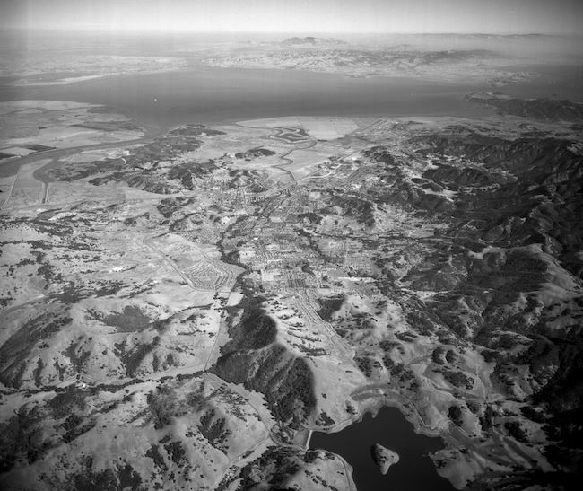
Central Marin Looking South, 1961
 You are soaring southward over the southern limits of San Rafael. Greenbrae and Kentfield appear in the foreground of your view; Corte Madera and Larkspur are to your right above Corte Madera Creek.
Notice Hutchinson Rock Quarry near San Quentin State Prison to the left, now the site of Larkspur Landing.
Photo ID no. 2006.34.07006
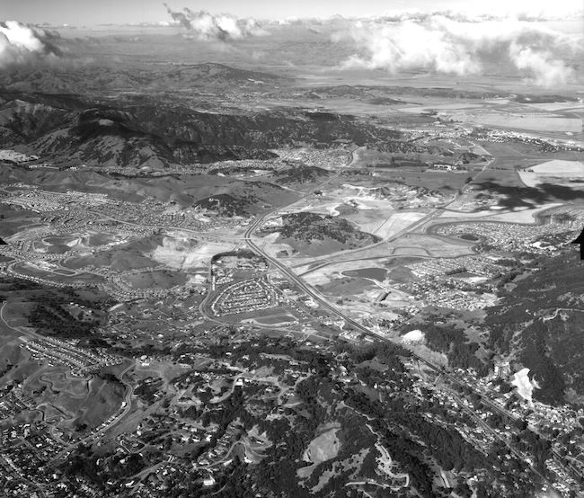
Terra Linda and Marinwood, 1960
 You are traveling north above Highway 101, the city of San Rafael behind you. Terra Linda is seen in the foreground; Lucas Valley Road and the neighborhood of Marinwood are seen up ahead.
Notice the fast-growing tracts of homes along Manuel T. Freitas Parkway and Del Ganado Road, a mix of Alliance and Eichler designs.
Photo ID no. 2006.34.05353
Point San Pedro, 1961
 You are flying south over San Pablo Bay, focused on Point San Pedro at San Rafael’s easternmost end. The Richmond-San Rafael Bridge’s misty span appears delicate in the distance.
Notice expansive Peacock Gap Golf Club, opened the year before this photograph, and North San Pedro Road winding along the coastline through China Camp.
Photo ID no. 2006.34.07069
San Rafael, 1965
 All of San Rafael can be seen in one lovely view when flying over the bay from Richmond. San Rafael’s downtown is seen to your left; Peacock Gap and the future China Camp State Park are to your right.
Notice the Marin Islands, West and East, about a mile from Loch Lomond Marina near Point San Pedro in the San Rafael Bay.
Photo ID no. 2006.34.10104
San Anselmo and Fairfax, 1966
 You are high over central Marin County looking southeast on an exceptionally clear day. Fairfax is to your right; San Anselmo and the heavily wooded areas of Ross and Kentfield are near the center of the frame.
Notice the rounded dome of Bald Hill to the far right and nearby Bald Hill Ridge Preserve, encircled by the cities of San Anselmo and Fairfax.
Photo ID no. 2006.34.10399
Mount Tamalpais and Three Lakes, 1964
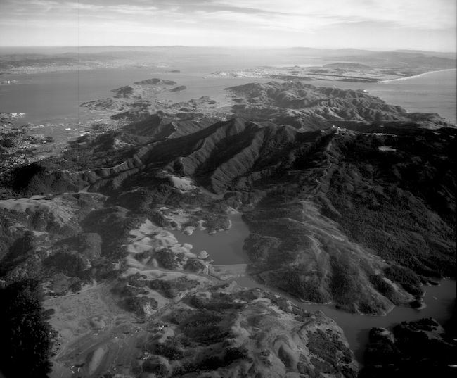 You are approaching the north side of Mt. Tamalpais, Marin’s majestic “sleeping maiden.” Three bodies of water map your flight path: Alpine Lake, Bon Tempe Lake, and Lake Lagunitas.

Notice Bon Tempe Dam, completed in 1948, separating Bon Tempe and Alpine reservoirs. The Mt. Tamalpais Watershed supplies Marin with most of its drinking water.
Photo ID no. 2006.34.08836
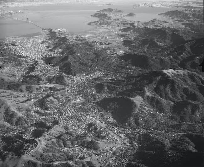
San Rafael and Terra Linda, 1962
 Cruising high over San Rafael Hill you see Terra Linda to your left and Santa Venetia to your right. The
Marin County Civic Center’s Administration Building, completed the year of this photograph, appears east of Highway 101 near the center of the frame.
Notice circular, tree-lined Mt. Olivet Cemetery and the future site of Northgate Mall, which opened in 1965.
Photo ID no. 2006.34.07906
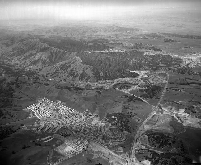
Novato, 1965
 You are flying east over Stafford Lake toward Contra Costa County’s Mt. Diablo in the distance. Novato, Marin County’s fastest growing city in the 1960s, is spread out before you.
Notice Novato’s waterfront community of Bel Marin Keys, early in its development, connecting to San Pablo Bay via Novato Creek.
Photo ID no. 2006.34.10096
West Marin, 1964
 Flying south along Marin’s west coast, you see Muir Beach, its homes perched on cliffs overlooking an inviting sandy shoreline. Shoreline Highway, designated State Route 1 the year of this photograph, disappears into the frame’s lower left corner.
Notice George Wheelwright’s Green Gulch Ranch, left of center, now the San Francisco Zen Center’s Green Gulch Farm.
Photo ID no. 2006.34.09007
Downtown San Rafael, 1962
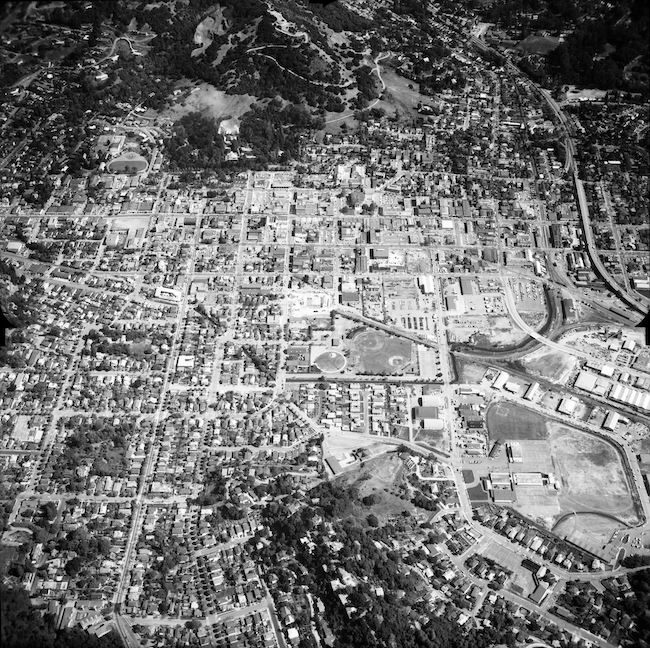 Floating over San Rafael, a crystalline view of the city’s downtown district comes into focus, bordered by San Rafael Hill to the north, Highway 101 to the east, Wolfe Grade to the south, and H Street to the west. The construction site in the very center of the frame is where today’s B Street Safeway stands.
Notice the Greek Revival-style Marin County Courthouse at Fourth and A Streets, burned down in 1971.
This photograph is on permanent display at The Boyd Gate House. Stop by to see it!
Photo ID no. 2006.34.07419

Sign up for our |
The Marin History Museum is a 501(c)3 non-profit organization.